| KSi | Knowledge Sciences, Inc. | |
| Terrain Analysis System - Implementation |
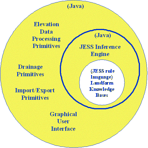
System StructureThe Terrain Analysis System (TAS) consists of object oriented processing functions implemented in the Java programming language. These functions can be used interactively by the user via the Graphical User Interface. However, when coupled with the JESS Inference Engine the facilities of the TAS can be used programmatically by IF-THEN rules thus providing a powerful automated analysis and interpretation capability. Elevation Data Processing Primitives The system uses a quadratic interpolation function to model successive local patches of the elevation data. A variable size window of digital elevation points is used in determining the quadratic coefficients that parameterize the surface. Using the quadratic characterization various morphometric derivatives are computed. These derivatives are then used to classify each elevation point as being part of one of the terrain related features: peak; pit; pass; ridge; channel; or plain. Other functions are used to segregate and delineate groups of these terrain features into region objects. Using other functions these region objects can be attributed using statistics such as: region area; perimeter length; compactness; minimum bounding rectangle; eccentricity; min and max elevation; and numerous moments (standard moments, normalized central moments, Hu invariant moments, etc.). In addition region texture attributes can be determined including: the first-order statistic roughness; and the second-order statistics homogeneity (energy), contrast (inertia), entropy, and correlation as described by Haralick [1973, 1979] in his papers on texture analysis. Functions exist that classify region object geometry relative to other region objects. Characteristics are determined such as: adjacency; degree of adjacency; and surroundedness. |
|
|||||
|
Drainage Primitives
Drainage is an important aspect in landform recognition. Various types of drainage maps can be generated via either the graphical user interface or via landform KB activation. Detailed attribution of the resulting drainage networks is available for use by the landform KB's to aid in the landform interpretation inference process. Refer to the page that further describes drainage processing. Landform Knowledge Bases The landform knowledge bases (KB's) are written in the JESS rule language and are executed by the JESS Inference Engine. The landform KB's implement the landform segmentation and interpretation strategies for each type of landform. This consists of applying the various drainage and digital terrain elevation processing primitives to generate attributed region objects. The rules of the KB are then used to infer particular landform types from the collection of objects, their attributes and the results of other landform KB's. Refer to the page that further describes lanndform KB's. |
Graphical User Interface
This graphical user interface allows the user to utilize the processing functions that are used by the knowledge bases. There are also graphical interactive functions that allow editing of landform delineation results that are produced by the automated knowledge base processing. Refer to the page that further describes the graphical user interface. Import/Export Primitives A set of data import/export Java primitives allow the input of various types of elevation datasets. Export primitives allow delineation results to be output in formats useable by other geographic processing software packages. Elevation data import:
Output file types:
|
|||||
|
Copyright © Knowledge Sciences, Inc. PO Box 3385, Ponte Vedra Beach, FL 32004-3385 904-280-7478 bleighty@knowsci.com
|
||||||